April will bring severe storms, snow and flooding as a wide-reaching storm crosses the US
(CNN) — April begins Monday, and Mother Nature is bringing everything but the kitchen sink. A multi-day system will slide across much of the country and bring the potential for tornadoes, large hail, flooding and even snow. As if that weren’t enough, there could also be record warm temperatures.
Widespread precipitation is expected as the very large system traverses from the Central US on Sunday to the Northeast by midweek. Snow and freezing rain will fall to the north, while heavy rain and severe thunderstorms unfold on the warmer side of the system.
April is traditionally when severe thunderstorm activity begins to ramp up. More than half of the tornadoes in an average year occur from April through June, according to the Storm Prediction Center.
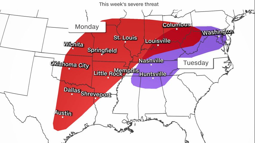
The weather this April is following suit. On Monday, severe thunderstorms are possible from northern Texas to southern Ohio. The main threats are tornadoes, damaging winds and golf ball-sized hail or larger. The best chance for severe storms will occur in the afternoon and continue through the evening hours. Nighttime tornadoes are more deadly, so make sure you have a way to get warnings if you live in these areas.
By Tuesday, the severe threat shifts east into an area from northern Mississippi to southern Pennsylvania. While tornadoes cannot be ruled out, the greatest threat here will be damaging winds.
The threat for flooding will be highest from Missouri through Pennsylvania beginning on Monday. As the storm progresses east, these areas could see rainfall totals of up to 3 inches through midweek.
One of the elements fueling the severe threat is the clash of cold air behind the system with the warm air out ahead. For some Southern cities, the warmth could break records.
Baton Rouge, Louisiana, along with Corpus Christi and Del Rio, Texas, could see record high temperatures on Monday. Laredo, Texas, could also break a daily record high on Monday if the city reaches its forecast of 101 degrees – its normal high temperature for July 24.
But while some parts of the South may feel more like summer, parts of the northern tier of the US will look and feel more like winter next week.
Snow as well as freezing rain could be the big threats from the Upper Midwest into the Great Lakes on Monday.
Rapid City, South Dakota, is forecast to pick up 3 to 6 inches of snow Sunday and Monday with high temperatures only in the mid-30s – the normal high for early February.
Minneapolis will see a mix of rain and snow, but even just an inch or two of snow will bring the city’s spring snowfall total to more than 16 inches – more snow than they picked up all winter.
By Tuesday, the snow and ice shifts to interior areas of the Northeast and in the higher elevations of the Green, White and Adirondack Mountains. Snow may linger well into Thursday. These areas could end up seeing more snow than the Midwest simply because of the longer duration of the snow event.
Snow amounts are subject to considerable change with the forecast still 3 to 5 days out, so keep checking back over the next few days for the latest thinking.
The-CNN-Wire
™ & © 2024 Cable News Network, Inc., a Warner Bros. Discovery Company. All rights reserved.
More News