Valley Organizations Working to Improve Storm Preparation Efforts
EDINBURG – Recent storms across the state serve as a reminder for residents of the power of Mother Nature.
The University of Texas Rio Grande Valley and county agencies are working to improve preparations before a storm strikes.
They’re doing so by creating 45 different models that cover different possibilities so people know what to expect, if and when a storm hits. The models will calculate how much an area will fall depending on the amount of rainfall in the area.
People like Bill Hiriak will be able to better prepare for heavy rains. He said his home was flooded in 2015 when heavy rains hit his Weslaco neighborhood.
“I started cutting four-by-four blocks to get the furniture up off the floor. We started saving everything we could, piling things on top of things, and it's just heartbreaking to see the water coming in and know you can't do anything about it,” he said.
Hiriak said the drainage in his neighborhood didn't hold after heavy rains.
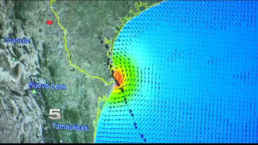
A professor at UTRGV wants to change that. Jungseok Ho is creating a reference tool for cities, counties, and those in the community can use.
“The target of this project is we're going to couple this hurricane storm surge and inland flooding event by any kind of rainfall event,” Ho explained.
He said the end result will be a coastal watershed flood routing model and a coastal storm surge flood map to predict inundation. One covers the chances of flooding based on routine rainfall and the other layers the element of hurricane waters, he explained.
The university is working alongside drainage districts and county emergency management offices to create an updated system. Together they've taken on the duty to map the entire South Texas Coastal Region.
Some communities don't have prediction models and those that do are outdated.
Urban development means less green space for water to be absorbed and a higher risk of floods.
The models will also improve evacuation routes. Additionally, cities will be able to modify their drainage system in communities prone to flooding with minimal rainwater; like Hiriak's neighborhood.
The 45 different models covering the entire South Texas Coastal Region should be complete by the end of 2020.
More News